Back to WATER INSIGHTS
By Tyne Eckmyn, Publishing Associate: Researcher and Writer at Save the Water™ | April 30, 2026
Edited by Apurva Makashir, Publishing Vice President at Save the Water™
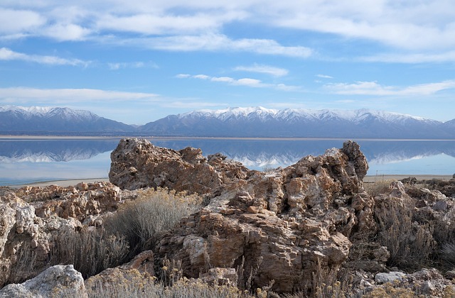
The Great Salt Lake lies in the southwestern United States. It is the largest saline lake in the western hemisphere, but in recent decades it has been shrinking. Today, it has already lost over half of its water. The exposed lakebed has caused dry sediments to be picked up by the wind, resulting in hazardous dust in the area. Additionally, it has also caused the formation of strange new geological features. These features have led to the discovery of an entire freshwater aquifer sitting just below the Great Salt Lake.
Most lakes have rivers or streams flowing out of them that carry away water and sediments. Terminal lakes, such as the Great Salt Lake, have no outflowing water. Water flows in, carrying dissolved and suspended sediments such as salt, but it does not flow out. Water leaves the lake via evaporation, leaving behind the sediments. As a result, the lake turns salty. The Great Salt Lake used to be part of a much larger terminal lake, Lake Bonneville, which was about the size of modern Lake Michigan. When Lake Bonneville dried up, it left behind the famous Bonneville Salt Flats.
The Great Salt Lake is supplied with water from three rivers. These rivers, and the region as a whole, have faced water shortages in recent years due to climate change.
Human consumption is the primary cause for the decline in the Lake’s water levels. Roughly 71 percent of the water is used in agriculture, and cities consume another 17 percent. Furthermore, dust from the newly exposed lake bed has been blown into both urban and agricultural areas.
This dust may be harmful to human health in multiple ways:
- Inhalation of fine dust particulates
- Inhalation of heavy metal contaminants in the dust such as arsenic and uranium
- Exposure to heavy metals in the soil through activities such as gardening or other activities
- Consumption of heavy metals from contaminated agricultural products
Strange circular mounds covered in vegetation developed in the dry lakebed due to the drop in the water levels. To investigate these strange mounds, piezometers were installed. They found that along the periphery of the mounds, the groundwater was salty, as expected, but became fresher near the centre of the mounds. Therefore, this indicates that there may be a freshwater aquifer sitting beneath the saltwater of the lake.
Furthermore, researchers conducted an Airborne Electromagnetic Survey (AEM) to map the extent and depth of the freshwater aquifer along the Lake's southeastern edge. The AEM survey measures the electrical conductivity of the water. Salt water and fresh water conduct electricity differently. Thus, the survey was able to indicate the boundary between the freshwater and saltwater. Researchers found that within the survey area, the freshwater aquifer may reach as deep as 3 or 4 kilometers. The results were then verified using sediment core samples and groundwater wells.
Additionally, the freshwater could be useful in mitigating the dust from the lakebed. It could be used to cover certain areas in water, making it harder for particles to be picked up by the wind. Also, it could also contribute to vegetation on the lake bed, stabilizing sediment and keeping it in place.
Further AEM mapping of the lake is needed to understand the full extent of the aquifer, and to develop plans for using it responsibly and effectively. This represents an exciting geological discovery and a promising new tool for dealing with the emerging risk of the lakebed's dust.
Save the Water™ is a 501 (c)(3) non-profit organization with a mission to conduct research to identify and remove harmful contaminants in water and to raise public awareness about water contamination and its health impacts.